 |
||
The Yale Alumni Magazine is owned and operated by Yale Alumni Publications, Inc., a nonprofit corporation independent of Yale University. The content of the magazine and its website is the responsibility of the editors and does not necessarily reflect the views of Yale or its officers. |
The Map That Changed the West When captains Meriwether Lewis and William Clark and the four dozen members of their Corps of Discovery headed up the Missouri River in May 1804, they had only the vaguest idea of where they were going and what they might encounter. “The best maps of the time were essentially a few incredibly sketchy lines on mostly blank pieces of paper,” says John Logan Allen, a geography professor at the University of Wyoming and an expert on eighteenth- and nineteenth-century American maps and mapmakers. “Lewis and Clark were not carrying AAA TripTiks.” But Clark was “a terrific cartographer with an instinctive feel for the landscape,” says Allen. At the end of most days throughout an epic journey that covered more than 8,000 miles and lasted nearly two and a half years, Clark would take a piece of sturdy rag paper from his carefully preserved supply and, with mortar and pestle, mix up an evening’s worth of powdered ink. With a fine-tipped quill pen—Clark plucked birds when the store-bought quills ran out—he would then turn his observations, interviews with Native Americans, compass measurements, and distance estimates into field maps that charted the largely unknown and often misunderstood territory from St. Louis to the mouth of the Columbia River in the Pacific Northwest. Not long after the expedition returned to St. Louis in September 1806, Clark, who settled in that city and became the federal government’s superintendent of Indian affairs, began consolidating what he’d seen and heard into a highly detailed manuscript. “I have visions of him in his study with his field maps and notes spread out, and as he’s compiling the document, Clark is being visited by every fur trapper, trader, and traveler who had been out West,” says Allen. “They picked his brains, and he would pump them for new information that he would use to fill in holes.” Completed in 1810, the Clark map is now in the collection of the Beinecke Rare Book and Manuscript Library. “The Clark Map pulled back the covers on the American West,” says Howard Lamar, Sterling Professor Emeritus of History. “When Thomas Jefferson sent Lewis and Clark out to explore, he dreamed they’d discover a new farmers’ paradise and a water route to the Pacific. What they found was very different.” The manuscript tells of both wonders and disappointments—of a land teeming with wildlife but often unfit for farming; of a Rocky Mountain chain bigger, more complex, and much tougher to cross than anyone imagined; and of rivers, rich with furs and fish, that didn’t provide a convenient cross-continental highway. Although it contained much misinformation, in offering a view of the West grounded more in reality than in hope, the map represents a “dramatic turning point in the American and European understanding of the geography of the far West,” says George Miles, curator of Western Americana at the Beinecke. Shortly after Clark inked in the final river and mountain range, he sent the map to Philadelphia to be printed as part of the official record of the expedition. More than 1,400 copies were produced, each with an edited version of the map folded and inserted into a pocket on the inside back cover. “They weren’t best-sellers,” says Allen; when Clark died in 1838, he still had 150 copies. But the manuscript was nevertheless supremely influential. It eventually found its way back to Clark, and travelers heading west stopped in to see him—he ran the permit office for travel in the region—to peruse the manuscript and the field maps and ask his advice about what lay ahead. “The manuscript also served as the template for every subsequent map of the West created in the first half of the nineteenth century,” adds Allen. “It was as good as it got.” Less than a decade after Clark’s death, U.S. Army captain and explorer John C. Fremont would take Western mapmaking the next step, correcting Clark’s misconceptions and filling in most of the remaining blank spaces. The Clark manuscript was folded up, and both it and the field maps became family heirlooms. They were eventually purchased, early in the twentieth century, by William Robertson Coe, a New York City insurance executive and avid collector of anything to do with the history of the American West. In the 1940s, at the request of Yale librarian James Babb, Coe decided to give a substantial portion of what by then had become a vast and important accumulation of history to the university. The manuscript and many other artifacts became the core of Yale’s Western Americana collection. The Clark map—its edges frayed, its paper yellowing, its black ink gone sepia—remains on display at the Beinecke. “This is a wonderful object,” says Howard Lamar. “This is the map that set in motion this country’s westward movement.”
William Clark drew his master map of the West on a sheet of paper 32 inches high and 52 inches wide. The linen-backed manuscript was informed primarily by the discoveries of the Lewis and Clark expedition, but Clark also attempted to include everything that other explorers had learned about the region between St. Louis and the Pacific Ocean. The map captures grand features of the landscape, such as ranges of the Rocky Mountains (2), and it also contains some details so fine they seem whimsical: Clark took note of the salt grass in an otherwise empty area south of the Arkansas River. In some places, he inserted pure fictions—such as the “Multnomah River” (5)—and in areas south and north of the expedition’s route where information was sparse, Clark tended to shrink distances and place geographical features too close together; for example, he radically compressed the coast of California south of San Francisco. The map, donated to Yale in the 1940s by the collector William Robertson Coe, now resides in the Beinecke. (Facsimiles printed for the 200th anniversary of the Lewis and Clark expedition are available through the University of New England Press.) For close-ups and more information about the numbered areas above, see the following pages.
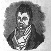
William Clark (1770–1838) was the expedition’s co-leader and chief cartographer. A Virginia plantation owner’s son, Clark joined the military at 19, where he met Meriwether Lewis and honed the leadership and wilderness survival skills the two friends would later need on their journey. After the expedition, Clark, whose diplomacy with Native Americans earned him the title of “red-haired chief,” settled in St. Louis and became superintendent of Indian affairs. |

|
|
|
|
|
|
|
|
©1992–2012, Yale Alumni Publications, Inc. All rights reserved. Yale Alumni Magazine, P.O. Box 1905, New Haven, CT 06509-1905, USA. yam@yale.edu |
||